Colorado VFR GPS Mountain Pass Waypoints
The first state in the continental U.S. to chart VFR GPS waypoints for mountain passes
Background
Navigating Colorado's mountainous terrain has long posed challenges for aviators. Thanks to a groundbreaking initiative led by the Colorado Division of Aeronautics, pilots now have VFR RNAV GPS waypoints for key mountain passes — charted on FAA VFR Sectional charts and available in aviation apps like ForeFlight.
The project was inspired by Alaska's mountain waypoint system. Colorado Aeronautics Director David Ulane and Aviation Planner Kip McClain collaborated with CPA's mountain flying experts to chart the safest and most commonly used routes through the Rocky Mountains. Colorado's approach accounts for the unique characteristics of its passes — higher elevations and shorter crossings that require pilots to cross at 45-degree angles rather than fly below weather systems.
Implementation Phases
Phase 1
May – July 2024
Ten waypoints covering Continental Divide passes added to FAA VFR Sectional charts and aviation apps.
Phase 2
Oct – Dec 2024
Ten additional waypoints, including four previously uncharted passes.
Phase 3
Jan – Feb 2025
Caution box added to VFR sectional charts; special notice in Southwest FAA Chart Supplement (p. 535).
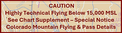
How Waypoints Appear on Charts

Using Waypoints in ForeFlight
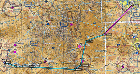
VFR GPS waypoints can be entered directly into your flight plan in ForeFlight, Garmin Pilot, and other aviation apps. They provide GPS guidance to the safest crossing points for each mountain pass.
Note: Chart detail is often not enough to visualize the path through the pass, so we recommend extra altitude, flying with an experienced pilot or instructor, or viewing a video of another aircraft traversing the pass in the same direction at a similar altitude.
Resources
- Colorado VFR GPS Waypoints List — Complete waypoint list from CDOT Aeronautics
- Interactive Mountain Pass Map — View passes and routes on the CPA map
- Mountain Pass Camera Status — Live FAA webcams at mountain passes
- Mountain Flying Ground School — Learn to use these waypoints safely